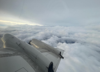
As a new tropical disturbance looms in the Caribbean this week during one of the most active hurricane seasons on record, airplanes and satellites are helping improve tropical storm forecasting.
The National Oceanic and Atmospheric Administration (NOAA) has counted 20 major weather and climate events in the United States so far this year, each costing about $1 billion in damages.
Since NOAA began tracking severe weather events in 1980, damage from the 396 tracked events is approximately $2.8 trillion, according to the agency’s website.
But critical weather data obtained by satellites or other means must be protected, particularly when traveling through a challenging environment such as a hurricane while being transmitted, Henrik Axelsson, chief executive at content delivery solutions provider KenCast, tells Connectivity Business News in this episode of “The Dish” podcast.

KenCast works on NOAA’s Hurricane Hunters program, which uses aircraft traveling through a storm to collect weather information in tandem with satellite data, Axelsson tells CBN.
“It’s quite challenging, as we’re literally on an airplane flying through a hurricane down to the ground, and there’s a lot of signal interruption,” Axelsson says.
For the program, NOAA’s weather monitoring aircraft are integrated with Norwalk, Conn.-based KenCast’s Fazzt Forward Error Correction (Fazzt FEC) digital delivery system, which is designed to protect mission-critical satellite and terrestrial data, even during network outages, Axelsson says.
“This use case is almost a perfect poster child for our solution,” Axelsson says, adding that Fazzt took about 30 years to refine.
Fazzt can be used for satellite and terrestrial data and for applications outside of weather monitoring such as automotive and maritime, but Earth observation has seen a pickup in demand, he says.
“I think in the last five years, we’ve seen a shift with data centers providing connectivity solutions partnering [with] satellite companies,” Axelsson says. “It just provides a lower barrier to entry for a lot of people, when they have one entity they can work with to provide the satellite connectivity and compute [the data] at the same time.”


